28 July 2023

On The Road Again - 6


My Summer Road Trip, part 6

I wasn't planning to visit Yellowstone National Park on this trip. However, once I got my Senior Lifetime Member card, the parks' the limit! I knew Yellowstone was near Bozeman, me being a map geek, so it seemed like something I should do, especially as I had begun sending selfies to my cousin by way of boasting about the many places I was visiting. A shot of me at Old Faithful would only add to my cousin's aggravation.

But first an oil change! Feeling a bit dry in the first leg of my travel, I thought I'd better get loaded up for my next adventure. So, first thing in the morning, I waited my turn at the Jiffy Lube in Bozeman, arriving before they opened but still only third in line on a Saturday.

Then I hit the road, driving south into the mountains, along the river, with a short stop at Big Sky to see what all the fuss was about (ski resort town), then creeping into the borders of the park as the highway went. Finally I arrived at the town of West Yellowstone where I met the tourists at the intersection of souvenir shops and amusements. The line to enter the park wasn't too bad - early in the season, recently opened - and I could use the member card line to speed past many of the folks who hadn't planned ahead. I had no particular agenda; indeed, if not for my Senior Lifetime Member card, I would feel obligated to make full use of my time in the park just to get my money's worth of the entrance fee.

For those of you who do not know, Yellowstone is the largest of the national parks and covers a huge area, mostly in northwest Wyoming but partly in Montana on the north and west sides and a little of Idaho on the southwest side. The whole thing sits over the hot spot of an ancient volcano. Hence, all the geysers and other geothermal activity. In fact, geologists are expecting it to erupt again rather soon. 

Trivia:used the coming eruption as a point in my futuristic dragon-heavy epic fantasy novel; the effects of the blast were felt as far away as the future remnants of Pittsburgh, PA, drying up the Ohio River and reshaping the landscape of the story - 8000 years later.

But I digress....

I had my map and I had my plan: get a selfie at Old 
Faithful to send to my cousin. So I followed the line of cars, moving at a steady clip, into the park. At times it didn't so much resemble a park as a wilderness. Plenty of forest and meadow with lots of elk out showing off. Fishermen along the stream. Finally arriving at a big intersection, I determined that everyone in the park today would be converging on Old Faithful, so I made a command decision to go the other way. That other way sent me north, ultimately to the north entrance and homeward. But I still had quite a way to go in miles - and dramatic mountain scenery I did not anticipate.

One reason I didn't plan to visit Yellowstone was because I had visited it as a boy on a family vacation trip. We did stop and see Old Faithful erupt then. For a young geologist wannabe, it was impressive. We waited for a second eruption. I couldn't remember exactly what our route was back then but as I drove north toward Mammoth Hot Springs, the resort town at the north end of the park, I didn't seem to remember seeing the area previously. At the end of the day, I was glad I visited the park again.

Glancing at my official park map, handed over gleefully to me by the pretty park officer at the entrance, her hair tied back in a tight bun, smiling at the presentation of my Senior Lifetime Member card, I noted the places to stop and see something. I needed a place that would scream "Yellowstone" so my cousin would be further annoyed. I considered stops here and there as I followed the other vehicles. There were places to pull over and others stopped, but some spots did not have (in my humble estimation) an easy in and out compared to the relative suitability of the location for photography (i.e., worth the stop?), so I drove on. I decided my best chance to get a good selfie with a background that would shout "Yellowstone" was what they called the geyser basin. A multicolored "hot pot" was the famous subject there.

I pulled into the parking lot, hit the lavatory, and hiked down the trail to get the view of, yes, a basin full of spouting vents. A vast field (definitely not a grassy field!), like a desert. With gas. I've always been sensitive to sulfur (Hawaii was a smelly experience for me.) so I cringed at the families taking their babies and toddlers in buggies down the trail. I could barely stand it long enough to take a few pictures. Then I returned to the gift shop and bought another, better map and a water bottle - a Montana brand which were in aluminum cans.
Continuing along the steep mountain roads, I eventually arrived at Mammoth Hot Springs. The grounds around the rustic hotel and shops were spotted with very tall elk making their way at a leisurely pace over to munching patches further afield. Everyone drove slowly to let them pass. I took a wrong turn trying to continue north and found myself instead heading out east to the northeast entrance, which would be much too far in the wrong direction. So, after a couple miles, I found a spot to make a U-turn and head back the way I came. 

As I approached Mammoth Hot Springs again, I had to stop for a huge mama elk who paraded onto the roadway where she paused as if playing crossing guard. Then, after checking me out, making sure I'd come to a complete stop, she glanced back over her shoulder and out from the brush bounded a little elk kid, as cute as could be! Both continued across the road and disappeared into the brush. There were other elk nearby that I managed to get pictures of, being stopped to let mama and child pass.
Then the real adventure began! The road continued north, but it began twisting and turning to hug the mountainsides and I was forced to view dramatic scenes of sharp drops and rugged slopes. There were few places to stop for pictures but one I did pause at was so crowded that many cars came close to bumping into each other as they jockeyed for parking spots. Otherwise, I thought it best to focus on driving the challenging road rather than trying to also snap a photo. Thus, I don't have a lot of pictures of that scenery.

The route winding down from the heights to the town of Gardiner, the village at the north entrance to the park, was quite grand, despite the gathering clouds which darkened the view. Arriving at the village after too many switchbacks and steering wheel clenching near-wipeouts, foot on the brakes, more elk greeted me. 

I came to the famous Roosevelt Arch where too many folks huddled to take their turns getting pictures; I slowly drove through, making them wait. I had to stop behind a car at the only stop light in the village and was about to honk for them to go on when suddenly I saw the elk strolling past in front of that car...and on to the souvenir shops lined up there, no doubt wanting a t-shirt. The elk seemed quite unimpressed with us mere humans.

I exited the park as the clouds darkened and drizzle fell. The road north to Livingston was less mountainous than the highway going south from Bozeman, but 
it had its own special scenery: grassy valleys and a snaking river, some patches of bare rock on the bordering mountains. From Livingston, I turned onto I-90 again and headed home to Bozeman. Dinner was at Taco John's.

NEXT: Three Forks & the Great Falls


--------------------------------------------------------------------- 
(C) Copyright 2010-2023 by Stephen M. Swartz. All Rights Reserved. No part of this blog, whether text or image, may be used without me giving you written permission, except for brief excerpts that are accompanied by a link to this entire blog. Violators shall be written into novels as characters who are killed off. Serious violators shall be identified and dealt with according to the laws of the United States of America.

21 July 2023

On The Road Again - 5

My Summer Road Trip, part 5

I didn't actually throw a dart at a map to decide where to go. I had a plan. After visiting three minor destinations (Cedar Falls, Waldorf College, Devil's Gulch), I drove on to visit three major destinations (Badlands National Park, Mt. Rushmore, Devil's Tower). After leaving Sheridan, WY, with a stop at the Little Bighorn Battlefield memorial and a detour through Billings, MT, I continued west on the orange-barreled I-90 to my next destination: Bozeman.
On the way to Bozeman I pulled into the only rest stop along the route (near Big Timber), with mountains rising on my left along the Wyoming-Montana border and pastoral hills to my right, and the darkening sky ahead of me as storm clouds billowed over the mountains to the west. The rest stop was surprisingly crowded with vacationers but I continued on.

As scenic as the route was
, I couldn't take any good pictures. The shaking of the car, the dirty windows, rain, and my speed prevented quality photography. Later, as I drove up and down narrow and curving mountain roads, I needed to focus of the road as much as I would've wished to take a dramatic shot. Seldom was there a place to pull over. Even when there were pullouts in the national parks I didn't want to stop at every one for a picture. So you get what you get here; I have the full pictures locked in my mind's eyes.
As I drove I was reminded of an episode from my youth. In one childhood road trip with my parents, we stopped at the small town of Livingston (just east of Bozeman) because my father wanted to visit a certain fly fishing supply store he'd read about in a fishing magazine. He wanted to get all the materials for making fishing flies (lures) and have me make some for him to use. I suppose he thought it would be cheaper than buying a ready-made lure. But I was the creative type and constructed all kinds of "flies" according to my whims, not matching flies based on actual insects that fish leap at. I used up all the materials and my father never caught any fish with the flies I made. 

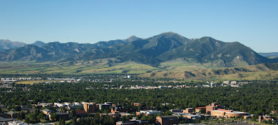
Why Bozeman? Besides being an excellent base for exploring the 100 miles in every direction, I'd gained an interest in the town because of a friend moving there (from Canada) and posting about her new life there over the past couple of years. It is a scenic place: forested mountains on all sides with grassy valleys sprinkled with cattle, and featuring Montana State University. I mentioned to my artist friend, who has designed many of my book covers, that I would be driving up there. She said she was going to Europe at that time but I could stay in her family's house. She gave me the door code but I politely declined, afraid of messing it up, and opted for a hotel by the I-90 exit.
The rain I met driving west to Bozeman intensified as I arrived and I struggled through the deluge, checking in and then going out for something to eat - all while everyone was heading home. I knew from maps there was a Barnes &Noble bookstore at a mall on the west end of town. I made my way there through a dark, rainy, rush hour on streets I only knew vaguely from what I remembered from the Google map on my phone. But I made it: dashed inside, got a hot coffee and an apple tart, then gathered some maps and browsed the shelves as usual, before returning back through the town to my hotel. With the rain continuing into the night all I could do was study my maps and plan my three days there.

The next day was much better: sunny and cool. First, I went to the Montana State campus and toured it almost like I was a prospective MSU parent. As is my quirk, I went through the library, hit the bookstore in the student union, checked out their selection of English textbooks and got a university logo t-shirt (Bobcats). 

Next, I drove around the town and the area, dodging more orange barrels, and noted what my friend had complained about: a cowboy town that grew a university was now a hipster community where many people flocked, expecting a paradise for ski bums and the freedom-loving camper crowd. (Wait until winter!) The expanding "suburbs" appeared rather Disneyesque as carefully planned neighborhoods, with a patina of artificiality that made you wonder if cameras were monitoring your every move. There seemed little of the rustic and country left outside the "old town" blocks. 

Indeed, apartment complexes sprouted everywhere, some yet under construction, hurrying to house the influx of new residents, far beyond just making more student housing. It wasn't unattractive, but I could understand how the locals would take the developments as a destruction of their traditional home. Honestly, I wouldn't mind living there, could wear cowboy boots and cowboy hat and speak with a country drawl.

When I travel, I like to imagine living in the place, seeing how life would be were I to be a full-time resident. I did that in Bozeman. I even shopped at Walmart, rubbing shoulders with the locals, much to their chagrin. But I had to be honest with myself: if I were a full-time resident, at any location, I'm likely to spend most of my time indoors, writing and reading, and only go out for errands - and that would be the only time I enjoyed the great outdoors. Now I'm no longer the great adventurer, ready to hike anywhere my whims lead me.

What else to do? I thought through my next novel as I drove, then typed notes in my hotel room. I watched TV. I downloaded pictures from my phone and my camera. I thought I'd seen enough of Bozeman. However, I realized that, using Bozeman as a base, I could visit Yellowstone National Park...because it was right there, 90 minutes south through the mountains, plus I already had my Senior Lifetime Member card.

NEXT: Yellowstone National Park


--------------------------------------------------------------------- 
(C) Copyright 2010-2023 by Stephen M. Swartz. All Rights Reserved. No part of this blog, whether text or image, may be used without me giving you written permission, except for brief excerpts that are accompanied by a link to this entire blog. Violators shall be written into novels as characters who are killed off. Serious violators shall be identified and dealt with according to the laws of the United States of America.

14 July 2023

On The Road Again - 4

My Summer Road Trip, part 4

If you've stuck with me so far, it's about to get better. I began with some minor goals, completed them, then swung out into the great unknown for bigger fish to fry. I toured the Badlands like yo mama did, then continued on for more, heading west to Rapid City.

As was my plan, I got off the dreadful I-90 and took a lesser highway south into the Black Hills, a mountainous region in the middle of vast prairie. When I was a boy, my parents brought me to Mt. Rushmore on a summer vacation roadtrip - and it was my intention to replicate such trips during this travel effort. I recall back when I was young, it was very impressive. On this day (same day I toured the Badlands, so it was afternoon now) I felt underwhelmed by the monument. You have to admire the carving skills, but we also acknowledge the desecration of the mountain that is a sacred place to the local Native population. In this visit, I did not have to use my Senior Lifetime Member Card - nobody was selling entrance tickets - but it did cost $10 for parking. It didn't seem too crowded at that mid-afternoon time so parking was not a problem. (Read more here.)

Following my I-90 plan, my next stop would be Devil's Tower just over the border into Wyoming. But I didn't think I could get there, sightsee, and then find a good place to stay for the night before sundown. So I decided to stop at Sturgis, SD, known for its motorcycle rallies. I like to stop about 4 or 5 pm and get plenty of time to rest, have dinner, offload my photos from my phone and my camera, and check the next day's weather, study my carefully folded paper maps and go to sleep early.

Not sure why impressive geological features are named after the Devil (Devil's Gulch, Devil's Tower, etc.) but they are. I'd seen plenty of pictures of this tower and I saw the E.T. movie which featured it, so I wasn't especially in an oo-ah mood when I first spied it while driving up the winding road to the site. Not so crowded in the morning when I arrived (9-ish) but was quickly filling up by the time I was leaving (10:30). I took my pictures, absorbed the ambiance of volcanic rock (granted, it was granite), and continued on to my next destination. I traversed lovely woodlands, and descended into a vast grassland devoid of any sign of civilization to the four horizons but for the powerlines strung along the road. Eventually I passed a large lake and began to wonder (glancing at my elegantly folded map) where the next gas station might be. (Read more here.)

I reconnected with I-90 and continued west to Gillette, WY, the nearest and next town of any size marked on my judiciously folded paper map. I exited and got gas. Down the main road there I saw the sign of a Taco John's restaurant and decided to have lunch since I was already stopped. Now, the tale of the Taco John is not widely known. In my youth, my cousin and I would hang out on Saturday nights, usually hitting the foosball parlor or shooting pool or otherwise courting mischief. But always we would make a pit-stop at the local Taco John's. I would always get their featured product: the Taco Bravo (a taco wrapped in a soft tortilla with frijoles as buffer, for a bigger, better taco experience). Then I grew up and moved away to places where no Taco John's existed. 
View of Bighorn Mountains from Sheridan, WY
So I had some nostalgia for a Taco Bravo...but it was the Super Burrito that caught my eye that afternoon in Gillete, WY. When traveling I always get out and go in to a restaurant (rather than use the drive-thru) because I like to stretch my legs and use the restroom. So I got my order, sat and enjoyed my meal. Feeling a taco-sized space in my belly, I decided to go back and get a Taco Bravo. Well, I don't know what the deal was but it didn't taste right, wrong seasoning, sauce too runny, so I didn't finish it. As I would discover, there are a lot of Taco John's scattered around the Western states and I would continue to patronize them as I traveled. I compared them, too. All subsequent TJs were better than the one in Gillete. (Sorry, Gillete folks, maybe it was an off day, who knows?)

I continued on I-90 to my intended destination of Sheridan, WY, just south of the Montana border. It's the obvious choice with not much to speak of for hours' driving on either north or south sides of the town. Trivia: my grandfather's middle name is Sheridan; he said he was named by his father after visiting the town back in its cowboy days. My grandfather was hardly a cowboy, however. I relaxed and planned my next day. I liked the hotel I was in and plotted to claim a room in the same chain at my next destination and made reservations by phone.

The next day, as was my plan, I headed north into Montana and stopped again at the Little Bighorn Battlefield Monument.
I say 'again' because I stopped there heading south in 2019 after coming down from Canada. In 2019 I paid the full price. In 2023 I used my Senior Lifetime Member Card to go in for free. But I did buy a t-shirt and a book in the visitor center. I did the full tour in 2019 so in 2023 I did the minimum: the walk to the hill where the actual last stand happened. Nearby, they have built a memorial to the Native warriors killed on that day; in 2019 it wasn't quite finished but now it was. It's always a tragedy, in my thinking, when anyone has to die in a battle (compare to Ukraine) and it matters less at the end of the day who was right and who was wrong. As a fiction writer I make my bed and sleep in it with the sheets of gray, never an easy black and white for anything. The shades of gray make the story interesting. Otherwise everything is Mary Sue and the boy next door, happily ever after, the end. (Read more here.)
I paid my respects and headed on to Billings, MT. My only reason to stop there was to seek out the taco shop I had a fabulous meal in coming south in 2019. I had stopped for gas coming from Great Falls but cutting across the interior grasslands/ranches rather than taking the southern interstate route. Next to the gas station was the restaurant. So in 2023, I drove through the city (I-90 at that point forced a detour on everyone anyway - straight through the downtown area, stoplight by stoplight thankyouverymuch.) but I didn't see what I was looking for. Doubling back, I joined the flow of traffic and saw a Taco John's (definitely not the same place I was looking for but it would do). A good meal, and I continued on, slogging along I-90 until it finally broke free into two-land full-speed interstate...all the way to Bozeman.

NEXT: The Bozeman Experience & Yellowstone


--------------------------------------------------------------------- 
(C) Copyright 2010-2023 by Stephen M. Swartz. All Rights Reserved. No part of this blog, whether text or image, may be used without me giving you written permission, except for brief excerpts that are accompanied by a link to this entire blog. Violators shall be written into novels as characters who are killed off. Serious violators shall be identified and dealt with according to the laws of the United States of America.

07 July 2023

On The Road Again - 3

My Summer Road Trip, part 3

I understand the expectation of an exciting, grandiose travelogue that thrills the imagination, but this is not it. It's personal. I had particular goals for my trip and I achieved all of them and went home. Not too exciting. But wait! There's more!

In both 2013 and 2019 my travel took me north along the extreme eastern edge of South Dakota. I wanted to go west this time. After visiting Devil's Gulch, about 5 miles inside of South Dakota, I proceeded westward and quickly found myself in vast grasslands. And the continuing I-90 construction project, often down to single lanes for 20 miles at a stretch.

Having seen it in social media posts, I wanted to visit the 50-foot tall statue called "Dignity" in the center of the state, on a bluff overlooking the Missouri River as it meanders south from North Dakota. I was excited as I approached the riverside town of Chamberlain and looking far ahead I could anticipate great views of the valley. I also craved a place to stop for a rest. However, the I-90 construction caused the exit ramp to the rest stop where the statue stood to be closed! I quickly looked around for other ways off the highway but there were none I could see as the road swung down to the bridge crossing the wide river. I could turn my head and catch a glimpse of the statue as I left it behind.

Disappointed, I drove on through the vast grasslands. My next destination was going to be the Badlands National Park, but measuring the angle of the sun and checking the fuel gauge, I knew I wouldn't make it today. I checked the map for possible towns with hotels. Never having gone this way, it was a bit distressing. I know the young whippersnappers would whip out one of them there smart phones and before you can say "G.P.S." they'd get me the name of a hotel I could stop at. Well, first, I was driving alone and handling a phone at the same time, especially in the concentrated manner required for research, would be dangerous and illegal. And, second, I had a good ol' paper map, folded properly, offering me the big picture, not some tiny square of what'sthatthere? nobody could figure out.
Fortunately, I decided on an extreme option: turning north into the great unknown (sure, I had a map but this spot was nothing but green) to find a room for the night in Pierre, the state capital. The trick was to boldly go where nobody but bison had gone before. Literally in the middle of nowhere. Grassland everywhere and a single strip of blacktop running to somewhere over the next rise. Eyes on the road, on the fuel gauge, out the windows on each side, calculating the time of the sunset. I arrived out of breath and found the small capital (15,000 people) to be charming, set on the edge of the Missouri River, upstream from the Dignity statue.
Being a state capital there seemed to be something going on that evening and hotels were full. I took a room nobody wanted: the Captain's suite in the ritziest joint in town, and paid dearly for it - but glad to have it! I had a fine Italian dinner in the restaurant next door and reviewed my plans in my room, soaking in the Jacuzzi tub (and used the shower stall in the morning). The next morning, gassed up and ready to go, I traversed the same road heading south through the grasslands with no other vehicles in sight until I reconnected with I-90.

Constantly checking my paper map, so elegantly and artistically folded, I eventually arrived at the eastern entrance to the Badlands National Park. My plan was to drive through it going west and exit back to I-90 to continue west. When I pulled up to the entrance gate, I saw that I could buy a senior lifetime membership which would pay for itself if I visited three national parks* - which I already planned to do on this trip.

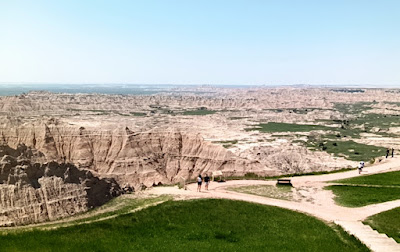
I will let the pictures do my talking. Let me just say, however, that this is one bad land. I mean, it is so bad yo mama wouldn't ever hike there! Sure, I'd seen pictures of the place but it's never the same seeing it for yourself. Sometimes it is underwhelming, often overwhelming. This badland view was initially overwhelming, stopping at one of the more famous view points. As I drove through and by much of the same kind of rock formations, it became less interesting. But I had my Senior. Lifetime. Member card and was determined to see everything.
As I drove along the winding, hilly park road, the landscape changed dramatically and it seemed I wanted to stop every mile or so to take more pictures. It took several hours to traverse the park, including a stop at the visitor center, walking through the geological museum, restroom, buying a Badlands t-shirt. I developed a sunburn, but I got plenty of fresh air and sunshine. I did not go on any hikes although there are plenty of trails. I was on a loose deadline, after all.


Then I exited - slowing for a herd of wild bison just sitting there off the road with no fence to keep them from harassing me - and entering the town of Wall, famous for its giant "drug store". It actually is a huge emporium selling all sorts of goods, not just medicine, and seems to occupy half the town. I had an excellent bison burger in a cafe inside the place but did not spend more time there than to browse a couple souvenir shops. It could easily be a full day's stop in itself.
But the day was still young and I calculated my afternoon: on to Rapid City, swing down to visit Mt. Rushmore, and then rush a little more back north for the night.

NEXT: The Four Tops and the Devil's Tower

*This is not the same National Park that features in my pandemic trilogy FLU SEASON.

---------------------------------------------------------------------
(C) Copyright 2010-2023 by Stephen M. Swartz. All Rights Reserved. No part of this blog, whether text or image, may be used without me giving you written permission, except for brief excerpts that are accompanied by a link to this entire blog. Violators shall be written into novels as characters who are killed off. Serious violators shall be identified and dealt with according to the laws of the United States of America.